VALLUMS IN DOBROUDJA / BESSARABIA AND PROTO-BULGARIAN THEORY
Author: Dimitar Krandjalov
ANTIQUE CITIES OF EASTERN THRACE (PROVINCIA EUROPA)
From 11 May 330 the political geography of Thrace was transformed by Constantine's new foundation at Constantinople. The creation of this new metropolis has inevitably overshadowed developments and changes in the cities of provincia Europa over the next three centuries yet these cities were also to benefit and develop from the proximity to the new imperial capital. The province of Europa was located at the extreme south-eastern end of Thrace in the peninsula formed between the Black Sea and the Sea of Marmara terminating in the east at the Bosphorous and the city of Byzantium, but also including the Gallipoli peninsula as far as the Dardanelles. Today the area forms the major part of European Turkey within the four vilayets of Istanbul, Tekirdag, Kirklarelli and Canakkale. Geographically, it is part of the south-east Balkans and the prominent ridge of the Stranja mountains runs from south-eastern Bulgaria along the northern half of the peninsula. This part of the region remains heavily wooded and there are few settlements on the Pontic coast. The only exception today and in antiquity is the small town of Midye (mod. Kiyikoy, anc. Salmydessos). A road is recorded in the itineraries along the coast but no trace is recorded along what is today a very rugged coastline. South of the coastal ranges the ground falls gently to the south and west, draining towards the valley of the Maritsa. This is open rolling country crossed by two of the great routes of antiquity and studded on prominent hilltops by the remains of Thracian and classical-period tumuli. The two roads which later ensured the prominence of Constantinople were the Via Egnatia, the imperial route linking southern Italy, northern Greece and Thessalonike with north-west Asia Minor, and the great military road from the Danube across Thrace which joined with the via Egnetia near Perinthos (Heraclea). From here the routes either lead to the crossing at the Bosphorous or more directly by sea from Perinthos to the Asiatic shore in the gulf of Nicomedia.
In Greek and early Roman times the most significant commercial centre of the north shore of the Propontis was Byzantium, but from the creation of the Roman province of Thrace the capital was its neighbor Perinthos situated 90 km to the west. Despite its distance from the heart of the old kingdom the site combined the advantages of road communications with a secure harbour and maritime links to Asia and to the Aegean. Inscriptions from the city attest a number of governors of Thrace as well as the "classis Perinthia". The province of Europa was created from the old early imperial province of Thracia at the end of the third century as part of the restructuring of the late antique provincial system. The principle city remained Perinthos, renamed under the tetrarchs as Heraclea, this was not only the metropolis of Europa but also the main centre of the diocese of Thracia, since an inscription of 324 records a "consularis provinciae Europae et Thraciae". This material will review the surviving archaeological and epi-graphic evidence from the cities of Europa in the period from 300-650 and will assess how their development was influenced by the creation of Constantine's new capital.
Perinthos-Heraclea
The city of Byzantium was only one of a number of cities which owed their foundation to Greek colonization, and the most prominent was Perinthos / Heraclea (mod. Marmara Ereglisi). This city preserves some of the most significant remains in the region including upper and lower circuit walls, a hippodrome, a theatre and the remains of a recently excavated early Christian basilica. Like Byzantium the classical city was located on a high promontory overlooking the sea and protected on the landward side by a narrow isthmus. The narrowness of the isthmus is today obscured by later coastal drift and river silting, but the reference in Diodorus Siculus (XVI, 76) that it was only one "stade" in width has been confirmed by a recent topographical survey. The main defences of the Greek city were limited to the north side of the acropolis although little now survives of the walls recorded in the siege by Philip II. Two great monuments survive from the Roman city. The first is the outline of the theatre located in a dramatic position overlooking the sea of Marmara and the island of Proconessus. This prominent site is very similar to the proposed location of the theatre of Byzantium, drawing another close analogy between the two cities. Only the outline of the "cavea" survives at Perinthos since the marble and stonework were robbed in Ottoman times. However, the setting and the size and its proximity to the great marble quarries at Proconessus ensure that it can be identified with the theatre at Heraclea recorded in one of the lists of the wonders of the ancient world. The second monument is the hippodrome. The date of this structure remains uncertain but it is situated outside the later walls at the foot of the Greek acropolis very close to the southern ancient shore line. Hippodromes are frequently associated with the new imperial capitals of the late third century, although at Perinthos the excavator believes it to predate these developments. At this period the city was renamed Heraclea, a name which may be associated with Diocletian and the Tetrachy and a porphyry head of a tetrarch from the site now in the Tekirdag Museum supports this association.
The major surviving monuments belong to the fourth and later centuries. These comprise a complex sequence of city walls and a large Christian basilica located on the north side of the city. The church was recently excavated and has revealed a richly decorated basilica probably dating to the sixth century and later modified on a much smaller scale in the middle Byzantine period. Two major circuit walls survive from late antiquity. The outer wall which includes the basilica is located in the lower town and extends across the ancient isthmus and returns along the south side. The main harbour was located in sheltered bay to the east, no traces of walls survive on this side, although the line of the sea wall may be traced along the foot of the north side of the acropolis rock and as far as the modern naval base. On the lower town wall there are at least two major phases both constructed in alternate courses of mortared rubble and brick bonding courses familiar in other Thracian cities. The walls on the landward side are less well preserved and the main gate to the city is probably located beneath the main modern approach road to the small Turkish town. On the south side walls and towers are well preserved, the angle tower is octagonal in form similar to the north-east angle tower at Hisar (Diocletianopolis) north of Plovdiv. Along this side which originally would have been much closer to the sea shore there are a sequence of large U-shaped towers similar in form and spacing to many of those preserved from the lower Danube fortifications of the later third and fourth century. From Perinthos this section of the fortifications can be dated by stamped bricks found in-situ in the walls and towers. These can be dated to the first half of the fifth century and they demonstrate some of the problems of dating structures on historical and typological grounds alone. Similar brick stamps have been located on the outer land wall but none were found in-situ and it is more likely that they reflect fifth century repairs rather the original construction of this stretch of the circuit.
An inner circuit of walls protected the acropolis and the presumed site of the Greek city, traces of the line can be followed within the modern town, but the most imposing remains are found on the south end of the acropolis overlooking the hippodrome. Structurally, we have observed that this part of the circuit can be seen to be later than the construction of alternating brick courses and rubble dateable to the fifth century noted above. The later curtain wall was built wholly of brick and it is flanked by two surviving pentagonal towers, one of which represents one of the most imposing late antique towers to survive from the Balkans. Unlike the curtain wall the pentagonal tower is built of alternating courses of brick with block work facings similar to those used in the Theodosius land walls of Constantinople. In date this part of the acropolis wall is clearly later than the fifth century curtain wall of the lower city and may perhaps be assigned to the reconstruction work at Heraclea undertaken by Justinian, although in Procopius's "De Aedificius" work is only reported on the palace and the renewal of an aqueduct. In the upper part of the tower there are two large embrasures for torsion artillery commanding the approach to the acropolis along the ancient shore line. The curtain wall and towers would have dominated this side of the city overlooking the hippodrome, where Heraclius was due to meet the Avar Khagan in 619, before he was forced to flee to the security of Constantinople. Although there are clearly two defended areas at Heraclea there is no evidence to suggest a reduction of the area of the city in late antiquity since the large basilica church is located parallel with the outer land wall on the edge of the north of the city. Other early churches may have been located below the middle Byzantine churches situated on the acropolis.
Selymbria-Eudoxiopolis
Much less structural evidence survives from the city of Selymbria (mod. Silivri) re-founded and renamed Eudoxiopolis after the sister of Theodosius II in the early fifth century, and one of a number of cities renamed at this time (e.g. Bergule/Arcadiopolis/ Theodosiopolis). The situation is a high bluff overlooking the sea with a sheltered harbour to the west, although the site lacks the physical protection of the defended promontories at Perinthos and Byzantium. The walls were largely demolished in the first half of the twentieth century although a photograph of Bulgarian soldiers taken during the Balkan war of 1912-1913 shows the east curtain wall surviving nearly to full height. This photograph confirms the sketches and plans made by the English chaplain John Covel in 1675. The wall was clearly of similar construction to the lower walls at Perinthos with alternating courses of brick bonding courses and rubble work. Covel's plan shows that the outline of the circuit wall was roughly rectangular in form although the area was significantly smaller than the acropolis at Perinthos. On the east side he indicates U-shaped projecting towers, together with trapezoidal towers of middle Byzantine date (with inscriptions of Basil I Seure). Photographs taken in 1912-1913 show these U-shaped towers still standing on the east side of the circuit. An important feature of the walls of Selymbria recorded in two sketches by Covel and still apparent in the photograph of 1912-13 was the survival of the wall top and the complex parapet above. On the full width of the curtain wall was constructed a series of arched casemates, themselves narrower than the full curtain and on top of which was an open parapet reached by a set stairs. Covel's drawings show both the inside and outside of the east curtain and it is clear that there were embrasures in the lower tier of the parapet works. In his illustration he indicates that the construction of the upper work was in smaller squared stones and was distinct from alternate courses of brick and stone construction of the main curtain wall. The photograph shows that in 1912-13 the cross walls of the casemates still survived and in one instance it is possible to recognize the vault of the casemate, however, the distinct stonework is not visible.
Similar features can still be seen in the late Roman curtain wall of Actia Nicopolis, although Gregory suggests that the upper wall was not offset at the front of the curtain wall to allow a walk-way behind. The application of a double parapet with arcades is a variation in military architectural practice known from some of the great fortifications of late antiquity, notably the arcaded curtain at the Honorius phase of the walls of Rome and the outer wall of the Theodosius land-walls of Constantinople. Significantly both these examples can dated to the early fifth century as a major period of innovation in urban fortifications. Later examples of arcaded curtains from the sixth century are known from Resafia in Syria, and are reported in the "De Aedificius" of Procopius, although at Resafia the casemates and the curtain wall appear to follow the pattern seen at Selymbria with a later additional wall added above. Double ramparts are noted by Procopius in his account of Justinian's works at Thermopylae, both on the long wall and on the fortress (De Aed. IV, i, 4-5) and also at Toperus in the province of Rhodope (De Aed. IV, xi, 16); no significant remains survive from Thermopylae but these would conform with works known from Selymbria. The closest analogy to the ramparts from Selymbria, however, is in Procopius' description of Justinian's restoration of the long wall across the Gallipoli peninsula or Chersonese, known in the Middle Ages as the Hexamillion. The description is worth quoting in full:
"So the emperor Justinian, with his constant solicitude for the safety of his subjects, did as follows: first of all he demolished the old wall, so that not so much as a trace of it was left. And he straightway erected another wall, upon the same ground, very broad and rising to a great height. Above the battlements a set-back vaulted structure in the manner of a colonnaded "stoa" makes a roof to shelter those who defend the curtain-wall. And other breast works resting upon the vaulting structure double the fighting for those who lay siege to the wall. Furthermore, at either end of the wall at the very edge of the sea he made bastions ("proboloi") extending far out into the water, which were joined to the wall and rivaled its defences in height". (De Aed. IV, x, 10-16)
Traces of the Chersonese wall were first noted in 1996, and although little survives of the curtain wall we were able to find the foundations of "proboloi" extending into the sea of Marmara. Returning to the walls of Selymbria the date of the main curtain wall can be attributed with confidence to the early fifth century when the city was re-founded as Eudoxiopolis from little more than a fishing village. Fragments of the walls which still survive in the modern town of Silivri closely resemble the fifth century work at Heraclea. However, the date of the works on the upper curtain wall are not certain, since as we observed above chaplain Covel clearly indicates a different form of construction for the rampart works. Selymbria (it retained this name in "De Aedificius") acquired additional importance with the construction of the Anastasius Wall, also known as the Long Wall of Thrace, at the beginning of the sixth century. In the section of the "De Aedificius" concerned with Thrace, Procopius clearly reports that the emperor undertook repairs to the walls of Selymbria as part of the general restoration of the Anastasius Wall (De Aed. IV, ix, 13).
Anastasius Wall
The Long Wall was originally constructed c. 500 by Anastasius and was a massive barrier wall running from the Black Sea to the sea of Marmara, west of Selymbria. In appearance the 56 km wall with regular towers and small forts was more like a grandiose frontier fortification but it was constructed as the outer defence of Constantinople at a time of increasing threats from the Bulgar tribes of Utrigurs and Kutrigurs, although it was also probably intended to protect part of the long-distance water supply of Constantinople which ran for more than 250 km from Bizye to the city. Throughout much of the sixth century the wall prevented incursions up to the walls of the capital and its immediate hinterland, but after the earthquake and a disastrous Bulgar raid of 557 or 558 Selymbria served as the base for Justinian's programme of restoration of the Long Wall. In practice there were probably two phases of restoration to the Thracian Long Walls in Justinian's reign, and the second occurred in 558-559 after the completion of Procopius's text of the "De Aedificius", so that the work on the Selymbria walls can be dated to the 540s. The Long Walls continued to be maintained until Heraclius' reign and they lastly figure in accounts of the Avar siege of 626.
Dating from this period is the hoard of early seventh century gold coins and Avar belt fittings now in the National Archaeological Museum in Sofia. These were found in 1913 when the Bulgarian army was besieging the Catalca lines (Filow, 1914), a modern successor to the Anastasius Walls, and must have represented the loot of the Avar invaders who like their twentieth century successors were turned back from the great city. The Anastasius Wall was maintained for little more than a century, but while this defensive line secured the city of Constantinople and its immediate hinterland it had the effect of both physically and mentally excluding some of the Thracian cities beyond it so that in 598 Maurice set off to campaign on the Danube by land as far as Selymbria but then took ship to Heraclea before taking the military road on towards Adrianople and Moesia.
Heraclea and Selymbria demonstrate major works of fortification in both the fifth and the sixth centuries. Evidence for other defences and monumental buildings in Europa from the cities of southern Europa relies on either epigraphic sources or textual evidence. Procopius reports work by Justinian to fortify the city and harbour at Rhaedestus (medieval Rodosto and modern Tekirdag) (De Aed. IV. ix. 17-21). An inscription of Arcadius dated to 395 and referring to the construction of walls, which is now in the Byzantine Museum at Thessaloniki, in fact originated at Panion (a small city further along the coast renamed as Theodosiopolis). These cities on the sea of Marmara originated as Greek colonies but other cities within provincia Europa are clearly Thracian foundations. Bizye (mod. Vize) was an important pre-classical centre and recent excavations by Edirne University have revealed the ancient theatre as well as the early circuit wall. Later medieval defences crown the hill overlooking the town and a large early Christian basilica can be traced below the important Byzantine church of Hagia Sophia. Bergule, on the main military road was renamed Arcadiopolis but little survives of the remains although a section of wall was seen, and significantly the earlier phase was of brick construction also noted at Heraclea and Salmydessos. The final new foundation of the late antique period was Derkos. This was small defended settlement located within the line of the Anastasius Wall. It was situated on a small peninsula at the east end of the Terkos lake. Statement was made that it was constructed by Anastasius in 507, but no other ancient sources are quoted.
Salmydessos-Medeia
On the coast of the Black Sea the only significant harbour in the province was Salmydessos (medieval Medeia, modern Midye or Kiyikoy). The promontory situation of the ancient and medieval settlement is reminiscent of other Black Sea harbours, notably Messembria. The town developed on high cliffs defined to the north-west by the valley and estuary of the Papuc dere and to the east by an inlet occupied by the ancient and modern harbour. The main curtain wall is located across the neck of land and prevents any access from the mainland. The curtain wall is largely constructed of brick with rectangular towers flanking the main gate but also including a wide pentagonal tower also constructed in brick. Recent studies mistakenly show these towers as curvilinear in plan, although they were correctly shown in the plan published by the Shkorpils in 1913 (Shkorpil, 1913). Although the towers are much eroded and despite the recent re-facing it is possible to confirm the observations of the 'Father of Bulgarian archaeology'. At the north end a section of the curtain wall with another gate and large circular angle tower are built of alternating courses of brick bonding and small rubble facings. The relationship between the two types of construction has been obscured by modern restoration, however the north work is probably earlier than the curtain wall and towers constructed solely in brick. Sections of curtain wall can be seen on the east side overlooking the harbour and there can be no doubt that the site was strongly fortified from late antiquity until the later middle ages.
No significant remains survive within the small modern town, however, beside the valley of the Papuc and less than 800 m to the south-east of the town are the remains of a spectacular rock-cut monastery traditionally dedicated to St. Nicholas. A plan was first published by the Shkorpils (1913) and it was later studied and surveyed by others, although the earlier plan shows the monument in greater detail. The most recent study suggests that the monument dates to the middle Byzantine period. Essentially it is composed of four main elements cut into the soft rock of the cliff face overlooking the north stream flowing to Midye / Kiyikoy. Rock-cut chapels and secular dwellings are known also from eastern Thrace, and also at Incegiz, near Catalca, yet none display the sophistication at church of St Nicholas. Significantly the interior of the "naos" is not defined as a variation of the cross-in-square, typical of many middle and later Byzantine rock-cut churches. But most important for the date is the decoration of the capitals in the 'baptistery'. In form they appear to mimic the complex marble capitals which are first recognized in Constantinople at St Polyeuctos in the early sixth century. Variations of these are found elsewhere in museum stores and gardens around the Black Sea at Odessus (Varna) and Amastris (Amasra), they are unlikely to date much later than the later sixth or early seventh century and it is possible to suggest that the form at Midye is also of this date.
Unlike the settlements and cities in Europa on the shore of the sea of Marmara, there is no mention of Salmydessos or alternatively Medeia in Procopius' "De Aedificius. Anchialos, the next major city to the north, rather eccentrically figures in Procopius' account of the eastern Black Sea in Book III where the natural springs and baths, and walls are noted (III, vii, 19-24) and also in the lists in book IV for Haemimontum (IV, xi, 20). The next significant city along the coast, Messembria, is also omitted by Procopius although it remains one of the most significant late antique and early medieval coastal fortresses of the western Pontus. The use of a very extensive brick-built curtain at Midye with large rectangular and pentagonal towers shows that even if the texts are silent the city underwent very major patronage at some stage in either the fifth or sixth century. All the comparative examples of brick-built curtains are major urban centres: Thessaloniki, Dyrrachium, Serdica, Philippopolis, Justiniana Prima, a section of the curtain wall at Messembria and the inner circuit at Heraclea which we noted before. The dates of these major imperial works range from the mid-fifth century (Thessaloniki) to the early sixth at Dyrrachium, although none of these dates are absolute and can be refined by future discoveries. Within Bulgaria it is also worth noting that there is a significant group of brick-built sixth-century churches, including St. Sophia in Sofia, Pirdop, Perushtica (phase 2) and Belevo. Another element common to many of these fortifications is the use pentagonal or prow-shaped towers. Examples of this form of tower are found at Messembria flanking the main gate, along the Anastasius Wall and at Heraclea on the inner curtain wall, associated like Messembria with a brick built curtain wall. Other examples of pentagonal and V-shaped towers are known throughout the Balkans. Almost all examples can be associated with major cities or fortresses. Thus although we have written sources confirming the continuing significance of Heraclea throughout the period, the architectural and archaeological evidence from the land-wall and also the rock-cut monastery from Salmydessos demonstrates a new importance in late antiquity even if this is not attested in Procopius' "De Aedificius". The similarities in design and wall construction might suggest a specific programme of works, however, without explicit evidence from literary sources or inscriptions it is better to regard these works as part of major initiatives over a broad period of time between the mid to late fifth and the later sixth centuries.
Jones (1940) in his discussion of the cities of provincia Europa observed that whilst the number of bishoprics did not significantly rise in late antiquity, the number of cities and new foundations increased along with the growing status of Constantinople. In part this can be attributed to the demand for resources and increased traffic towards the new city. But if we consider the physical and textual evidence for these cities the two main aspects are fortifications and churches, common enough themes in late antiquity. Procopius adds other details from time to time in "De Aedificius", but some of these may have been added merely to provide a little variety in what was after all a literary text, which as the lists in book IV demonstrate could become excessively dry. The overall impression from the survey of these cities is very different from a study of provincial cities in either Asia Minor or Thrace in the mid-third century or earlier. With the exception of Heraclea, the main period of imperial intervention begins with the house of Theodosius, continuing under Anastasius, and then throughout Justinian's reign. The urban pattern is of small cities, well defended as in the case of Selymbria and Salmydessos, which were to survive into the middle ages and later. In many ways these cities belong to a new pattern seen also north of the Stara Planina at the rebuilding of Nicopolis ad Istrum in the mid-fifth century, with a strongly defended circuit including a prow-shaped tower and a new basilica. But perhaps a closer analogy with some of the cities of Europa, such as Salmydessos, was the late antique fortifications and settlement preceding the medieval capital of Veliko Tarnovo. A strong hill-top site this comprised major new fortifications and a number of sixth century basilicas. However the pressure of external raids and invasions did not diminish and these settlements did not survive the end of the sixth century. In contrast, in provincia Europa the principle factor underpinning revival of urbanism was the empire's need for defence and more particularly the security of the capital. Since the death of Valens and the defeat of the field army at Adrianople in 378, Constantinople could not rely on the Danube frontier for its security and what emerged was a developing pattern of defended cities along the major roads and new barrier walls in the Balkan passes and across the Gallipoli peninsula. These were constructed in the fourth and fifth centuries and eventually culminated with the construction of the Long Walls of Thrace, simply called by Malalas 'Wall of Constantinople'. The City survived the Avar siege of 626 although in the aftermath the last remnants of the imperial limes, the Long Walls of Thrace, were abandoned. Faced with new challenges from the Bulgars under Asparuch the emperors continued to fortify a sequence of defended cities and fortresses in eastern Thrace, maintaining an urban pattern established for the protection of the great cities.
***
MIGRATION OF UNOGUNDUR-BULGARS OF ASPARUKH FROM THE LAND OF AZOV TO THE LOWER DANUBE
The Bulgars of Asparukh occupied the easternmost part of Great Bulgaria, which disintegrated after the death of Asparukh's father khan Kubrat. Asparukh had for eastern neighbors the Khazars and thus his Bulgars were the first to face the Khazar onslaught in mid-VIIth c. Unable to resist, they had to retreat to the west.
The Byzantine chronicler Theophanes provide evidence for the settling of Asparukh in the Lower Danubian lands: 'At last the third of them (the brothers), called Asparukh, after crossing Dnepr and Dnestr rivers which are to the north of Danube, and after capturing the Oglos (Onglos), settled in the lands between it and the aforementioned rivers, because he noticed that that place was protected and difficult to attack from any side; being swampy in the front and from the other sides - surrounded by a ring of rivers, it offered great security against enemies for the weakened by the parting people'.
Almost identical is the information of the patriarch Nicephorus. According to him the place of refuge was called Onglos (Oglos). The story of the subsequent battle of Asparukh against the Byzantine emperor Constantine IV provide more info about the location of the Onglos: 'And the emperor Constantine, learning that a ungodly and filthy people settled in the lands beyond the Danube, in the Oglos, and that they attack and devastate the lands near the Danube, i.e. the presently held by them country, previously held by the Christians, was very upset and ordered for the departure of all troops to Thrace. And after arming the fleet, he set against them by land and by sea with the intention to make war with them and to chase them out. The infantry moved in battle lines towards the so called Oglos and the Danube and the fleet was ordered to anchor nearby. The Bulgars, seeing the dense and numerous lines, became desperate, fled in the aforementioned fortification and prepared themselves for defense. In the next 3-4 days nobody of them dared to show up and the Romans did not seek a battle because of the swamps. The filthy people, seeing the Roman weakness, recovered themselves and became bolder. The emperor suffered from a fit of gout and had to return to Messembria to take baths, leaving his generals to start the fighting and to engage them in a battle if they leave their fortifications. Otherwise, to put them under siege and to check their advances. The cavalry, however, spread the rumor that the emperor was deserting them, and fled on their own, without being chased by anybody. The Bulgars, seeing this, attacked and chased them and killed most of them by swords, and many were wounded. And after chasing them up to the Danube, they crossed it'.
Particularly important in the above passage is that the Onglos was a system of fortifications, which the Byzantines could not overcome despite their numerical superiority. This information significantly facilitates the localization of Onglos, which otherwise could be placed anywhere - in the south, in the north from the Danube delta or even in Wallachia.
The archaeological investigation revealed that the earliest type of Proto-Bulgarian defenses in the Lower Danube region (the second half of the VIIth c. - VIIIth c.) were the earthen ramparts and ditches. The earliest ones, undoubtedly built before the year of 680 (the year of the Constantine debacle) are the Southern Bessarabian rampart and the Galac fortified camp. The total length of the north-facing Southern Bessarabian rampart is 126 km, its mean width - up to 31 - 41 m. Its western end is 35 km, and its eastern end 28 km from the Danube. Immediately next to its western end is situated the fortified camp at Galac, which encompasses the land between the rivers Seret and Prut and is surrounded by water from three sides. The more vulnerable NW side was protected by a rampart and ditch with total length of 27 km, very similar in structure and dimensions (42-43 meters mean width) to the Southern Bessarabian rampart. Two more fortification are situated to the south of Danube: the Little Dobrudzha rampart and the Nikulicel fortified camp. The Little (Southern) Dobrudzha rampart covers the narrowest part of Dobrudzha, between the Danube and the town of Constanca, and it is the oldest of the three earthen ramparts in Dobrudzha. The other two - the Large earthen rampart and the Stone rampart are to the north of it and face the north, while the the Little Dobrudzha rampart faces the south. The Nikulicel fortified camp in Northern Dobrudzha was protected by an intricate system of earthen ramparts, it encompassed an area of some 48 km2 and could serve as an excellent refuge for a numerous population.
All these data show that an identical in structure system of defenses was built on the both sides of the Danube. Both in the south and in the north there was a fortified camp and it obstructs the equivocal location of the Onglos, used as a refuge by the Bulgars of Asparukh. Most popular is its identification with that part of Southern Bessarabia, which is surrounded by the South Bessarabian rampart. Others identified the Onglos with the Galac fortified camp. K. Shkorpil proposed that initially, up to the 60s of the VIIth century, the Bulgars of Asparukh settled in Southern Bessarabia and built the Southern Bessarabian rampart for defense against the Khazars. Later, they occupied Northern Dobrudzha and built the Little Dobrudzha rampart against the Byzantines. His opinion was further elaborated and this is the generally accepted reconstruction at present. Accordingly, the Nikulicel fortified camp was the centre of the Asparukh territory, some 15,000 km2.
The archaeological and textual evidence reveal that the led by Asparukh Bulgars, who settled on both banks of the Danube delta, were a relatively numerous group of nomads, with a robust military organization and significant experience in the military engineering, which allowed them to built an extensive system of defenses in a relatively short period of time.
***
Addendum: We proceed in straightforward manner our efforts to consolidate a story of Bulgarian archaeology. Up until now there are the following useful materials available in the booklist — cf., D. Dimitrov's "Introduction to Archaeology", V. Mikov's "Guide to the Archaeology Museum", K. Troshev's "Skorpil Brothers - Known and Unknown Facts", and V. Velkov's "Serdica - Sredetz - Sofia". See also the commentaries and picture material included within.
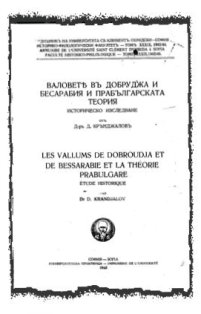
Thus we add a new name to our booklist, D. Krandjalov (no biography data available). From cross-reference sources there appeared only two matches: — 1) D. Krandjalov. Les vallums de Dobroudja et de Bessarabie et la théorie protobulgare, Godisnik na sof. Universitet, XXXIX, Sofia, 1943, p. 1-158; and, 2) Congress of Roman Frontier Studies, 1949, ed. Eric Birley. (Durham: Durham University, 1952) ... "D. Krandjalov's theory endorses of a Domitianic date for the 'Great Earthwork', as well as a pre-Roman dating for the 'Small Earthwork' and a Constantinian dating for the stone wall ... Against this claim of a Bulgarian origin for all of them, Krandjalov advances a very carefully documented and closely argued case in favour of a Roman origin for most".
The thesis that the Bulgars never-come / never-go at the Balkan Peninsula is not new. For instance, Dr. Gantscho Tzenoff argued for 30 years with Prof. V. Zlatarski and the Bulgarian Historical Association. Tzenoff lost his Chair at Sofia University, but received wide acclaim in interwar Germany (Berlin) where he was undisputed authority "on the historical development of Roman Empire limes". The story of Dr. Dimitar Krandlalov is almost the same, wherever the latter explored the development of the Roman Limes on the Middle Danube area and towards the river's Black Sea delta. Here we can cite two more Krandjalov's works on the "Early development of the Rumanian Language", and the "History of Yugoslav People". These books are not readily available in Bulgarian language, but the author of the review have seen them in litto-print.
D. Krandjalov was jack-knifed from Bulgarian archaeology by the early 1950s. This didn't change, however, the overall picture of Stalinism and Soviet dogmatism that has started to prevail in the circles of Bulgarian Academy of Sciences. Have in mind that Krandjalov was only one from a whole plead of talented scholars that were shunned by the Communists. The story reads as following:
Prof. Bogdan Filow, long term Chairman of the Bulgarian Archaeological Society, was executed by the People's Court; albeit, his numerous publications are still difficult to obtain as sources (luckily, we managed to find his last unpublished manuscript on "Outlines of Archaeology" which is litto-print but is extremely important textbook, first of its kind as history of world archaeology in Bulgarian language).
Prof. Geza Feher was extradited from Bulgaria in 1945 and never admitted again in his second adopted country. His numerous contributions on Bulgarian history and archaeology are priceless. G. Feher managed to launch firmly the hypothesis of Eastern links of the Bulgarian people with Persian culture and other associated studies to the Mesopotamian diocese. Even if not indigenous and barbarian people, the Bulgarians carried for 2000 years in their tour-de-force a culprit from the Middle East.
Prof. Rafail Popov died in 1940 from Lyme disease in the Madara caves, an untimely loss. Besides his longtime friendship with American archaeologist James H. Gaul (1911-1945), who published posthumously in English the "Neolithic Period in Bulgaria" (1948), R. Popov's efforts in the field of Prehistoric Archaeology are invaluable. Recently it appeared that last manuscript on "Prehistoric Bulgaria" was contained by his son and published posthumously in "University Library" (1943).
The rest from the golden pre-WW II Bulgarian Archaeology Society members were scattered by the new realities. They could never embed themselves in the lines of the new totalitarian Soviet science. Evidently, some of them were put into pressure to publish their old works under revised editorship (Prof. G. Katzarov, Prof. D. Dechev, Prof. S. Romanski, Prof. S. Mladenov, etc.) This had proved a desiderata for the Communists who, firstly, ought not have the nerve and ability to distort the evident truth; and, secondly, would remain wholesale "iron-masks" of their eminent predecessors. This inevitably led to chaos in science and humanities, something that couldn't be repaired in the long run until today.
Let us finish this review on Archaeology in brief. The book at hand, as we already mentioned, was an outlier in Bulgarian archaeology literature. It didn't have kin research to corroborate its findings. In the following 40 years or so, there appeared several monographs from Bulgarian authors that tried to refute D. Krandjalov's theory of the Roman limes. What we have tried to do here in this presentation is two-fold. Firstly, an overview is given from an article at the "Conference on Classical and Late Antique Urbanism" — jointly attended by Bulgarian Academy of Sciences and the British Archaeological Academy in 2002. The locust is elsewhere (Provincia Europa or Eastern Thrace) but the theme is same (building circuit curtain walls or ramparts). Immediate transition of this idea to the Eastern Roman Empire is the construction of same fortification vallums in Syria, Egypt and finally towards the Great China Wall. If the Romans didn't expanded so much farther to the East, we couldn't see reason to expect someone else with the technical genius to do so.
The Bulgarians proudly wanted to be called a civilization, however, realities were too pragmatic to allow such metamorphosis. In reality those barbarians, and their ancestral relatives the Huns, were and remained allegedly a ferocious warriors clan. Their success to conquer territories and adjoining cultural requisite was solely due because of the sorority of their numbers. Any other admission of nomadic intransience is inacceptable and unserious. Thus the Bulgars were just another migrant population mass that was assimilated and later civilized by their supposedly enslaved and encumbering victims (Romans, later Byzantines).
Last words for the newest archaeological research on earth-and-wood ramparts (which is already not so new since it dates from the 1970s and 1980s). Consider the monograph from D. I. Dimitrov "Proto-Bulgarians at the North and West Black Sea", which is entirely written with sponsorship from Soviet Archaeology. Don't confuse this work with research from D. P. Dimitrov, who is archaeologist from the old generation. Next see to excavation and field work from Rasho Rashev. The latter has published numerous articles and monographs on early Proto-Bulgarian fortifications. In our opinion, at least half of those quarries concern mounds but not earth-and-wood ramparts, ditto.
Pictures 1, 2 & 3: Sample illustrations on the text above.
|
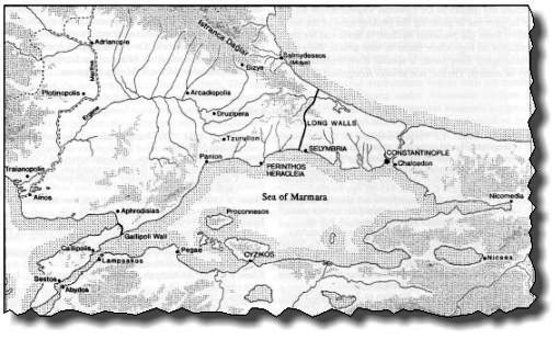
(i). This is Provincia Europa (Eastern Thrace) of the Byzantine / East Roman Empire c. 600. Devastated by Goths and Avars, the Bulgars were another wave of invaders.
|
|
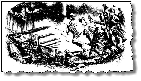
(ii). The fortification tactics of the Bulgars were successful at defending the new lands, by beating the Byzantine enemy at their own game. See those fire-hardened wooden crunches stirring from the earthen ramparts.
|
|
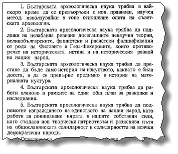
(iii). This is the full story of Bulgarian archaeology from second half of 20th century. Note the five articles at the First Archaeological Session at BAS (1950) — Sovietization, anti-Filow and -Geza Feher directives, materialistic approach, planning of excavations / research, and creative patriotism / solidarity.
|
Copyright © 2011 by the author.